Hey, weather watchers! Dust off those snow boards, metre sticks and thermometers, because the IRG Weather Net will start for the 2024-2025 season on Monday, November 4, 2024 and run every morning at 7:30 a.m. Atlantic Time. Net control will be shared by Rick VE9MTB and Scott VE1CSA. They will gather your local observations and send them off to Environment and Climate Change Canada. ECCC uses the reports to fine tune their predictions and issue alerts in severe weather conditions. The reports are also used by other agencies such as River Watch and news media.
Weather
Weather-related information, including monthly climate summaries for New Brunswick as compiled by Environment and Climate Change Canada.
Radio net frequencies for hurricane activations
When hurricanes or tropical storms threaten, The Hurricane Watch Net activates on 14.325 MHz and 7.268 MHz, and will use either or both of these frequencies as propagation allows.
If conditions require, a CANWARN Net may be activated on all or part of the IRG system. Be sure to listen to and follow the instructions of the net control station in giving any reports - report only what is asked --and remember the important ABC's: Accuracy, Brevity & Clarity.
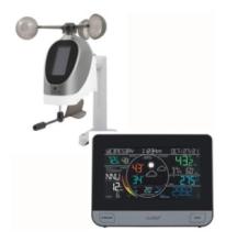
Win a LaCrosse weather station
Update! The winner of the draw for the new LaCrosse weather station was VE9GM, Gino Mazerolle of Drummond, NB. Congratulations, Gino! Thanks to all who participated, and keep on providing those observations.
To celebrate the 30th Anniversary of the WeatherNet, Scott VE1CSA and Rick VE9MTB want to thank everyone who’s checked in over the years allowing the reporting of over 600,000 pieces of data to the Atlantic Storm Prediction Center.
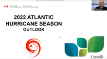
2022 Atlantic hurricane season outlook
Bob Robichaud (VE1MBR), Warning Preparedness Meteorologists for Environment and Climate Change Canada, presents the outlook for the 2022 hurricane season in Canada.
View video at: https://www.facebook.com/EnvironmentCanadaWeather/videos/5150563611694194/ (approx 6 minutes)
IRG Weather Net ends another season
The IRG Weather Net held its last daily net for the 2021-2022 season on Friday, May 6. Over the last eight months, observers contributed an estimated 25,000 items of data to help Environment Canada, N.B. River Watch, and other agencies in their forecasting.
January 2022 review and February (winter/spring) outlook
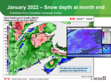
January had below normal temperatures (-1.5ºC) and slightly below normal precipitation (95%) in comparison with the 30-year climate normal (1981-2010) for the province. Despite having below normal precipitation, extreme southern areas saw above normal precipitation with Moncton reporting their 4th snowiest January on record. Edmundston reported their 5th coldest January on record.
December 2021 review and January (winter) outlook
December had above normal temperatures (+1.9ºC) and below normal precipitation (81%) in comparison with the 30-year climate normal (1981-2010) for the province.
November 2021 review and December (winter) outlook
November had slightly above normal temperatures (+0.9ºC) and slightly above normal precipitation (108%) in comparison with the 30-year climate normal (1981-2010) for the province.
Climate event of the month: In keeping with the climate event from October, Charlo reported a minimum monthly temperature of -5.4ºC and Bathurst reported -6.5ºC. These were the warmest minimum temperatures on record for the month of November.
October 2021 review and November (fall/winter) outlook NB
October had much above normal temperatures (+2.7ºC) and below normal precipitation (72%) in comparison with the 30-year climate normal (1981-2010) for the province.
Charlo recorded their warmest month on record with most sites reporting their top 5 warmest.
September 2021 review and October (fall) outlook
September had above normal temperatures (+1.5ºC) and much above normal precipitation (196%) in comparison with the 30-year climate normal (1981-2010) for the province. Bas-Caraquet, Bathurst and Woodstock recorded their wettest months on record and Edmundston saw its third wettest month on record.